Bulkhead Replacement and Repair
Steel, vinyl, composite and heavy timber, with the tiebacks, deadmen and drainage that decide the next wall's life. SJRA permits a replacement as it permits a new run.

The dam is here. The river authority's Lake Conroe office is here. So is the wide southern basin, where a norther runs the length of the lake before it reaches the bank — this is where the rules and the wave energy meet.
Conroe began in 1881 as Conroe's Switch, where Isaac Conroe put up a sawmill; the economy ran on lumber and then on oil after the Conroe field was discovered in 1931. Today it is the county seat of Montgomery County, growing at a pace visible in its own published figures: the city's GIS department reports 56,207 residents at the 2010 census and 89,956 at the 2020 census, with a Census Bureau estimate of 114,581 in July 2024. City limits cover 77.6 square miles against an extraterritorial jurisdiction of 403.0 square miles.
That curve is the demand story for waterfront work, but it carries a jurisdictional wrinkle. The ETJ boundary has moved twice recently — Resolution No. 2910-08 took it to 3.5 miles on passing 50,000 population, and Resolution No. 4843-25 to 5 miles on passing 100,000 — and the Conroe Planning Area, the regulated portion of the ETJ, was repealed on 11/8/2018. Much of what carries a Conroe mailing address on the water is unincorporated Montgomery County, so the honest description is Conroe and the lake's southern and eastern shore, and the honest advice is to check the address rather than assume it.
The south end is developed, armored and older, which makes replacement the dominant job rather than first construction.
Steel, vinyl, composite and heavy timber, with the tiebacks, deadmen and drainage that decide the next wall's life. SJRA permits a replacement as it permits a new run.
Fixed and floating structures set to the 201-foot pool, and to whatever seasonal schedule the authority runs when a cap elevation is set.
Slip and access-channel depth work, permitted alongside the wall. Material can be pumped for backfill reuse rather than trucked off site.
Covered slips and entertainment structures that take southerly wind through an open gable rather than stand against it.
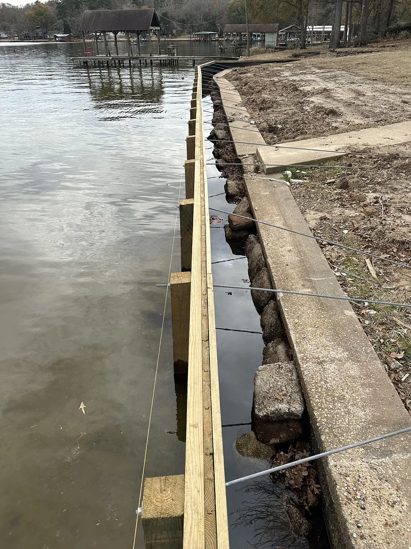
New sheet piling with a treated timber wale and cap, driven just outboard of a badly failed concrete wall, steel tie-back rods running back over the old structure.
That is why SJRA treats a replacement as construction rather than repair — the new line is not where the old one was, the anchorage is new, and the drawing has to show it. The reservoir-wide view of Lake Conroe covers water conditions across all of it; this page goes deeper on the authority whose office sits in this town.
The permitting office is a Conroe address: SJRA's Lake Conroe Division, 1577 Dam Site Road, 77304, on 936-588-3111.
SJRA's definitions do most of the work. Authority Land is property owned or controlled by the authority in connection with the dam and reservoir, generally including easement rights, rights of way and any land which is, may be or has been inundated by the reservoir, up to a contour line 201 feet above mean sea level. Translated: at or below 201 you are on SJRA ground and need SJRA authorization. Above it you are generally on your own land — but SJRA holds recorded flowage or flood easements from 201.0 up to 207.0 mean sea level, and the permittee agrees to comply with what they restrict.
The rule owners find hardest is Section 6.01: the right to build, place, operate and maintain private structures, marinas, bulkheads and other encroachments on the reservoir or Authority Land is not an inherent right that comes with the control or ownership of waterfront property. SJRA adds that a permit can be revoked at any time, and that the authority is under no obligation to maintain a specific reservoir level to facilitate the use of encroachments. Only two things are exempt: personal property that is immediately removable, and landscaping with its irrigation, installed by the adjoining owner.
Vocabulary is worth knowing, because SJRA uses both words. It titles its own pages Licensing My Residential Structure and Permitting My Bulkhead, and files a dock and a wall as separate applications on separate tracks — even though its overview sentence lists residential bulkheads under licensing. The practical point is that a dock authorization does not cover a wall, and the bulkhead rule names replacement explicitly: it is a violation to install, re-install, replace or modify bulkheads except in strict compliance with a valid permit. Section 6.06(d) also requires that dredging, filling and bulkheading work be performed in accordance with all applicable regulations and permits of the U.S. Army Corps of Engineers, Galveston District.
The bulkhead submittal is four items: application, subdivision approval, property survey and construction plans. The survey must come from a Registered Professional Land Surveyor with the bulkhead location marked, and the plans must identify all proposed materials and show placement relative to the property lines. The form asks for the contractor's business name and phone, and SJRA's internal review block includes a contractor compliance check — the authority looks at who is doing the work, not only what is being built. What SJRA does not publish is a numbers table: no setback figure, no maximum dock length, no square-footage cap. Any page quoting a specific Lake Conroe setback is quoting something SJRA never wrote.
Geometry, not a statistic — and the strongest engineering argument here.
The southern end is the wide basin nearest the dam, at the downwind end of a lake running roughly 21 miles north to south whenever a norther is blowing. Regional winds are south to southeasterly most of the year and turn northerly in January with frontal passages, so a shoreline at the south end, looking north up the lake, takes the longest uninterrupted run of open water when a norther comes down the long axis. Canal frontage reaching the main lake through a dredged channel is the sheltered counter-example on the same shore. That is reasoning about orientation and prevailing wind, not a measured wave height — and it is why two walls a mile apart get designed differently.
Worth checking per address rather than assuming, because the boundary has moved recently. The city's GIS department reports city limits of 77.6 square miles against an extraterritorial jurisdiction of 403.0 square miles, and notes that Resolution No. 2910-08 expanded the ETJ to 3.5 miles on passing 50,000 population while Resolution No. 4843-25 expanded it to 5 miles on passing 100,000. Much of what carries a Conroe mailing address on the water is unincorporated Montgomery County.
Yes, and the rule names replacement specifically. SJRA states that it is a violation for any person to install, re-install, replace or modify bulkheads in the reservoir or on Authority Land at any time except in strict compliance with a valid permit authorizing it. The application itself carries checkboxes for a new bulkhead, a repair in the existing location, and a repair in a new location.
To the San Jacinto River Authority's Lake Conroe Division, 1577 Dam Site Road, Conroe, Texas 77304, on 936-588-3111, filed through the SJRA customer portal. The bulkhead submittal is four items: the application, subdivision approval, a property survey and construction plans. The survey must come from a Registered Professional Land Surveyor with the bulkhead location clearly marked, and the plans must identify all proposed materials.
No, and SJRA states it as plainly as a rule can be written: the right to engage in construction, placement, operation and maintenance of private structures, marinas, bulkheads, buildings and other facilities or encroachments on the reservoir or Authority Land is not an inherent right that comes with the control or ownership of waterfront property. The authority adds that a permit can be revoked at any time.
For the heavy work, yes. SJRA's rules require that any dredging, filling or bulkheading work be performed in accordance with all applicable regulations and permits of the U.S. Army Corps of Engineers, Galveston District. So a bulkhead or dredging project here sits under a federal layer as well as the river authority's, on top of whatever the subdivision and the county require.
Tell Dave what is standing on the frontage now and how it is failing. The survey, the SJRA filing and the design get handled as one package — and if the address turns out to be county rather than city, that is sorted before anything is drawn.