Call Dave: 936-662-5100
Lakes We Serve · Montgomery County, TX

Bulkheads, boathouses and dock work on Lake Conroe.

TPWD's description of the lower lake is one sentence long and tells you what the market is: bulkheads with boat docks dominate the shore. This shoreline is already armored — so most of the work here is replacing, repairing and extending walls that were built a generation ago.

The Permitting Reality

Elevation 201 is the trigger, and SJRA licenses the work.

San Jacinto River Authority, Lake Conroe Division — 1577 Dam Site Road, Conroe, Texas 77304, 936-588-3111.

SJRA owns and maintains Lake Conroe and its dam, and its Lake Conroe Division is responsible for regulating and licensing activities on the water — commercial operations including marinas, boat and personal watercraft rentals and construction businesses, plus residential docks, boat slips, residential bulkheads and water sales for landscape irrigation. A permit is required for docks, boat houses, bulkheads, dredging and any encroachment at or below the 201-foot normal pool elevation, and the authority states the rule without hedging: no person shall construct, operate or maintain a private bulkhead on Lake Conroe at any time without a proper permit.

Applications are filed through the SJRA Customer Portal at customerportal.sjra.net, and three things go with them. First, the application. Second, an existing survey by a Registered Professional Land Surveyor showing metes and bounds with the proposed bulkhead placement marked — and, where the work sits on SJRA property, documentation proving the homeowner is authorized to encroach. Third, construction plans specifying the proposed materials for all structures and their placement relative to the property lines. SJRA also warns in capitals that any change to the bulkhead or added items requires contacting the Operations Department for additional approval before proceeding.

Two things sit on top of that. On the land side, Montgomery County or the cities of Conroe, Montgomery or Willis may require building, floodplain, drainage or right-of-way permits. And at the upper end the shoreline abuts roughly 5,000 acres of Sam Houston National Forest, where the U.S. Forest Service is the landowner rather than SJRA — a different conversation entirely. Worth knowing too: the City of Houston holds two-thirds of the water rights, which is why Houston has a voice in lake-level operations even though SJRA runs the permitting.

Completed bulkhead holding a green lawn in front of a large lakefront home, with a newly built timber bulkhead running along the near shoreline
Our Work on This Lake

The lawn stays where it is.

Finished bulkhead protecting a lakefront home's lawn, with a new wall running along the near bank — the photographs on this page are Shoretech's own completed shoreline work.

A wall that holds is mostly what you cannot see: embedment depth set to the soil, tiebacks and deadmen sized to the load behind it, and drainage that relieves pressure instead of building it.

201 ft
Normal pool msl — at or below it, everything needs an SJRA permit
1–3 ft
Normal annual fluctuation per TPWD — steadier than most Texas lakes
2/3
Share of the water rights held by the City of Houston
5,000
Acres of Sam Houston National Forest at the upper end, where the Forest Service is landowner
Bottom, Bank and Level

Sandy to silty — friendly ground for driven pile.

Conroe holds its level better than most Texas reservoirs, and the bottom is forgiving. The complications here are regulatory and neighbourly, not geological.

TPWD's substrate description is short: substrates range from sandy to silty. Compared with a limestone lake where every foundation is a rock socket, that is a straightforward place to drive pile. Riprap sections are common along the developed edge, four constructed fish-habitat reefs have been placed by TPWD and partners, and aquatic vegetation is currently low density with slight to moderate algal staining. The lower two-thirds of the lake is open water; standing timber follows the old river channel in the upper reaches, and the upper reservoir inside Sam Houston National Forest is described as primarily featureless shoreline.

Conservation pool is 201 feet above mean sea level, holding 411,022 acre-feet, and TPWD rates normal fluctuation at just 1 to 3 feet. Layered on top of that, SJRA and the City of Houston have operated a flood-mitigation drawdown program since 2018 — the published seasonal schedule took the lake to 200 feet msl in spring and as low as 199 feet in fall, and later descriptions refer to a smaller April-through-June storm-management drawdown. Because the exact drawdown decides where a bulkhead cap or a slip elevation lands, Shoretech confirms the current terms with SJRA rather than working from an older schedule.

Published figures for the lake's size differ, and are worth stating as such: TWDB gives approximately 19,640 acres at the 201-foot pool, TPWD publishes 20,118, and local sources go higher still. TPWD does not publish a maximum depth at all — the numbers in circulation for the old river channel run roughly 70 to 79 feet — and the commonly quoted 157 miles of shoreline comes from boating and tourism sources rather than SJRA or TWDB. The lake runs about 21 miles top to bottom across Montgomery and Walker Counties on the West Fork of the San Jacinto River; the dam was completed in January 1973 and the lake filled that October 31.

Scope of Work

What Shoretech builds on Lake Conroe.

Engineered, permitted, inspected work — which is what this lake expects.

Bulkhead Replacement & Repair

The core of the work here. Galvanized steel, vinyl, FRP composite and heavy timber walls replacing aging runs on an already-armored shoreline — with the tiebacks, deadmen and drainage that decide how long the next one lasts.

Custom Boathouses

Entertainment-grade boathouses with open-gable cooling, lifts, lighting and storm-rated substructures, built tight to a shoreline that barely moves.

Boat Docks, Slips & Piers

Fixed, floating and swim structures set to the 201-foot pool and to whatever seasonal drawdown SJRA currently operates.

Precision Dredging

Slip, shoreline and access-channel dredging permitted alongside the wall — material pumped for backfill reuse instead of hauled off by truck.

Bulkhead Lines

Planned as one system.

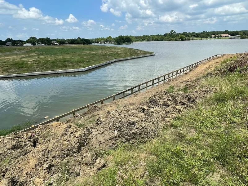
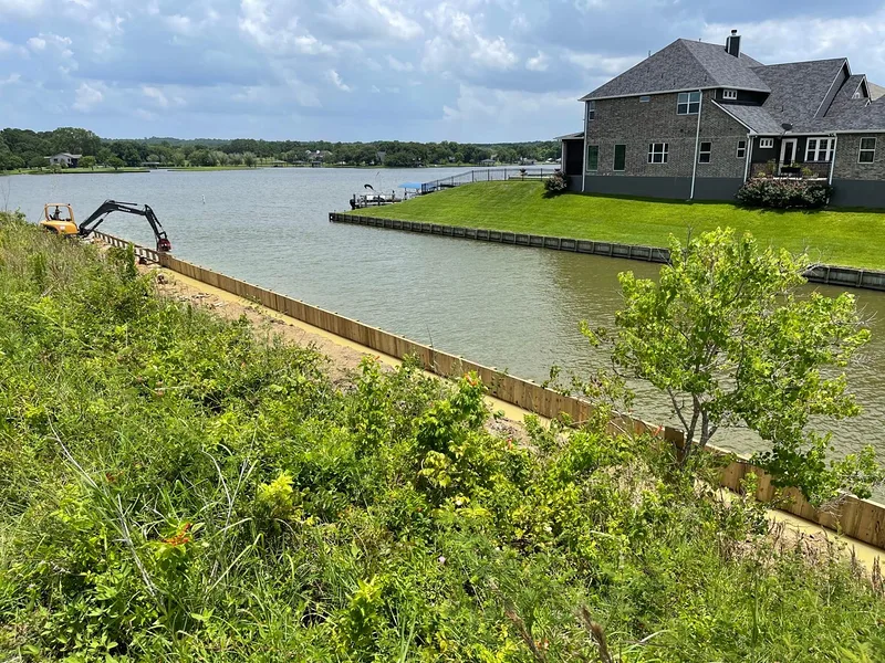
A concrete-capped bulkhead wrapping an entire subdivision shoreline, and an excavator backfilling behind a newly installed timber run — the same wall, at two stages of the work.

Wide view across a subdivision lake with a concrete-capped bulkhead wrapping the far shoreline and new timber bulkhead framing along the near bank Excavator working on the bank above a long run of newly installed timber bulkhead, seen from the water, with subdivision homes behind
Around the Lake

The gated communities, the marinas, and three islands.

Only the southern third of the lake is inside the city of Conroe. Everywhere else, people say where they live by the community name.

Communities we serve here

  • Bentwater
  • April Sound
  • Walden on Lake Conroe
  • Corinthian Point
  • Seven Coves
  • Conroe
  • Montgomery
  • Willis
  • Panorama Village

Marinas, ramps and landmarks

  • Stow-A-Way Marina & RV Park, Willis
  • April Plaza Marina
  • Seven Coves Marina
  • Private marinas and yacht clubs at Bentwater, Walden and Corinthian Point
  • Scott's Ridge and Cagle Recreation Areas — Forest Service ramps
  • Lake Conroe Park and the free FM 830 public ramp
  • Bird Island, Pax and Noah Island

Bentwater is the upscale gated waterfront with a yacht club, marina, 18-hole golf course and fitness and tennis facilities. April Sound and Walden pair lakeside living with country-club amenities and their own marinas; Corinthian Point is a quieter established community with a marina and pool; Seven Coves anchors the Willis side. Across all of them the expectation is the same — surveys, stamped plans, permits and inspections rather than informal construction.

Questions We Hear

Lake Conroe FAQ.

What needs an SJRA permit on Lake Conroe?

Docks, boat houses, bulkheads, dredging and any encroachment at or below the 201-foot normal pool elevation. SJRA's Lake Conroe Division states the rule flatly: no person shall construct, operate or maintain a private bulkhead on Lake Conroe at any time without a proper permit. Applications are filed through the SJRA Customer Portal at customerportal.sjra.net.

What goes in with the application?

Three things. The application itself. An existing survey by a Registered Professional Land Surveyor showing metes and bounds with the proposed bulkhead placement marked — plus, if the work sits on SJRA property, documentation proving the homeowner is authorized to encroach. And construction plans specifying the proposed materials for all structures and their placement relative to the property lines.

My bulkhead is permitted. Can I add a deck or change the cap?

Not without going back first. SJRA warns in capitals that any change to the bulkhead or added items requires contacting the Operations Department for additional approval before proceeding. On this lake the permit covers what was drawn, not what the wall becomes later.

Is the lake still being lowered seasonally?

Confirm the current terms with SJRA rather than relying on an older published schedule. SJRA and the City of Houston, which owns two-thirds of the water, have operated a flood-mitigation drawdown program since 2018; the published seasonal schedule took the lake to 200 feet msl in spring and as low as 199 feet in fall, and later descriptions refer to a smaller April-through-June storm-management drawdown. The exact drawdown matters when a bulkhead cap or a slip elevation is being set, so it is verified, not assumed.

What drives bulkhead and boathouse cost on Lake Conroe?

Wall height and the length of the run, what stands behind it — tiebacks, deadmen and drainage are sized to the load, not the footage — whether an old wall has to come out first, water depth at the face, soil that runs sandy to silty, access to the shoreline, and the material: galvanized steel, vinyl, FRP composite or heavy timber. The survey and the SJRA application are part of the scope too. No two frontages price out the same, which is why Dave looks at the wall before putting a number on it.

How long does a Lake Conroe project take, start to finish?

The permit comes first: the surveyor's drawing and the construction plans go to SJRA through the Customer Portal, and building starts once the permit is issued. From there the schedule depends on scope — a dock goes faster than a full bulkhead replacement, and a replacement runs longer than new wall on open bank because the old structure comes out first. The lake level and any current drawdown schedule figure into the sequencing, and Dave gives a schedule with the proposal.

Has Shoretech worked on Lake Conroe?

Yes. Lake Conroe is core service area — a short haul from the Trinity base — and Shoretech's record here includes subdivision shoreline work: continuous bulkhead lines and shared-access waterfronts planned as one system rather than lot by lot. The photographs on this page are Shoretech's own completed work.

Start With a Conversation

Planning a project on Lake Conroe?

Tell Dave what is standing on your frontage now, how the existing wall is failing, and what you want the finished waterfront to do. The survey, the SJRA application and the design get handled together.