Bulkhead Replacement
Galvanized steel, vinyl, FRP composite and heavy timber walls for an already-armored shore. SJRA permits a replacement as its own action, so an old wall is never quietly swapped out.

Here the architectural committee is a separate body from the POA, the gate has published contractor hours, and the river authority permit voids itself if the deed restrictions were not satisfied first. Sequence is the whole job.
The City of Montgomery sits at the junction of TX 105 and FM 149, about 15 miles west of Conroe, near the southwestern edge of Sam Houston National Forest at roughly 300 feet of elevation on a little over five square miles. It is one of the oldest towns in Texas — a trading post in 1826, founded in July 1837, when W. W. Shepperd laid out a townsite on 200 acres he had bought two years earlier, where the Lake Creek Settlement had stood, incorporated in 1848, and the first county seat of Montgomery County. The city also calls itself the birthplace of the Texas Lone Star Flag through Charles B. Stewart, a claim flag historians dispute and one worth repeating as the city's own rather than as settled fact.
None of that is waterfront. The frontage carrying a Montgomery mailing address is the 77356 belt on the west and south shore — Walden's peninsula with its yacht club and two private POA ramps, gated Bentwater with its staffed main entrance, and April Sound on the southern shore with its own marina and covered slips. Most of that belt lies in unincorporated Montgomery County rather than inside city limits, which decides who reviews the land side of a job. It also holds the widest range of budgets on the lake, from million-dollar lakefront down to townhouses and condominiums.
Galvanized steel, vinyl, FRP composite and heavy timber walls for an already-armored shore. SJRA permits a replacement as its own action, so an old wall is never quietly swapped out.
Entertainment-grade structures drawn to survive two reviews — the community's architectural committee and the river authority — on one set of plans.
Set to the 201-foot pool. SJRA calls a residential dock a licensed structure rather than a permitted one, with a recurring annual fee based on size and location.
Depth restoration in cove and canal berths, filed alongside the wall so one mobilization covers both.
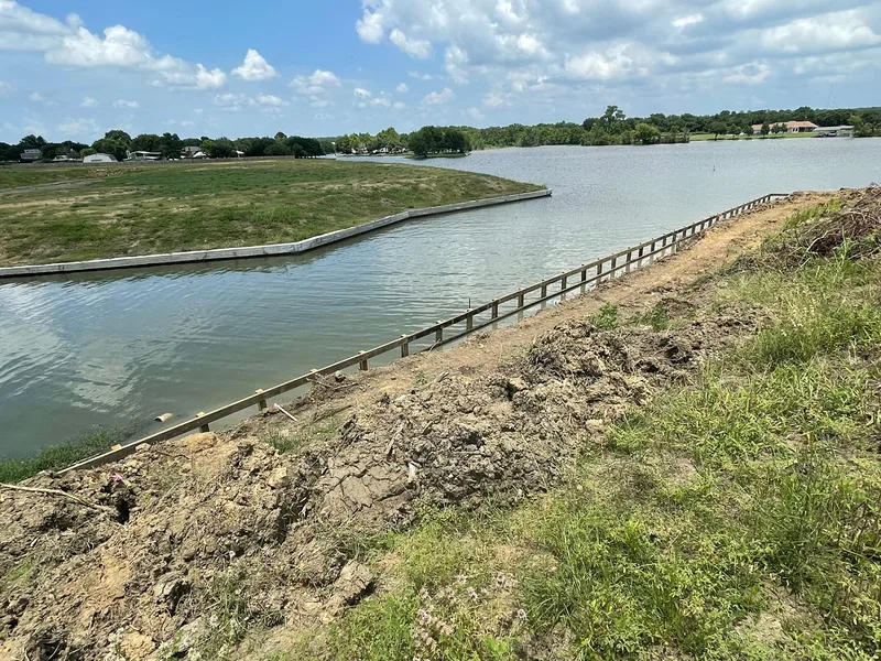
A concrete-capped bulkhead built by Shoretech on Lake Conroe, wrapping a subdivision shoreline as one continuous system.
That is the scale a community waterfront needs: one wall line, one drainage strategy, tiebacks sized to the load behind them. Shoretech has been building waterfronts for more than 40 years from a base in Trinity. The lake-wide picture on Lake Conroe covers the water and the authority; this page is about what changes when the address is Montgomery.
Community review here is not a courtesy step ahead of the real permit. It is the condition the real permit rests on.
SJRA defines Authority Land as reaching up to a contour line 201 feet above mean sea level, which puts the waterward end of every wall, slip and boathouse on the authority's ground rather than the owner's. Above 201 the land is generally private, but SJRA holds flowage or flood easements around the reservoir perimeter from 201.0 up to 207.0 mean sea level, described by metes and bounds and recorded with the county. On a shallow-sloping west-shore lawn that six-foot band reaches a surprising distance inland.
Then comes the sentence that decides the order of work. The permittee warrants the structure violates no deed restriction or covenant, and that if it does, the permit becomes automatically void without any action on SJRA's part. Nobody has to catch it; nothing has to be revoked. A wall built on a valid-looking permit but against the covenants was never authorized at all.
Bentwater makes the separation explicit: the Architectural Control Committee is created through deed restrictions, and the POA acts as communicator and coordinator for the ACC, an entity independent of the POA. Bentwater also publishes a contractor entry schedule — crews and trucks in after 7 AM, work Monday to Saturday 7 AM to 7 PM from June 1 through September 30 and 7 AM to 6 PM from October 1 through May 31, a 9 AM start on Sundays and six named holidays, and no entry or work at all on Thanksgiving Day or Christmas Day. The West Entrance, open 6 AM to 10 PM, is the contractor gate, and the owner registers the crew through the POA's online entrance system.
Walden reviews on a fixed cadence: the ACC meets every other Tuesday, submissions are due by noon the preceding Friday, and plans must be approved before work begins. Its restrictions run section by section, so what Walden allows varies by street. April Sound is governed by seven elected trustees managing over 40 acres of common area, a guardhouse and gate, a marina with covered slips and three parks. The land side is county work — a drainage signoff at 500 cubic yards of fill or excavation or a retaining wall 3 feet or higher, floodplain review within 100 feet of the floodplain or floodway, and permits that expire one year from approval. Which body reviews a lot is an address-level question, the same one the buildability check answers elsewhere.
Lake Conroe runs roughly north to south for about 21 miles, so the long fetch axis is north-south and a west-shore lot generally looks east. Regional winds are south to southeasterly most of the year and swing northerly in January with frontal passages, so a cove opening north or south sees more wave energy than an east-facing pocket. April Sound's southern-shore position and the exposed tips of the Walden peninsula are the higher-energy ground; deep coves and canal lots are the sheltered counter-example. That is reasoning from orientation and prevailing wind, not a measured wave figure — and it is how a wall gets sized here.
Usually the county — most of the 77356 waterfront belt lies outside city limits in unincorporated Montgomery County, and the city itself is inland. County Engineering requires a drainage signoff at 500 cubic yards of fill or excavation or a retaining wall 3 feet or higher, and floodplain review applies within 100 feet of the floodplain or floodway. Confirm per address before assuming which office reviews it.
No, and the POA says so itself. Bentwater states that the Architectural Control Committee is created through deed restrictions, and that the POA acts as the communicator and coordinator for the ACC, an entity independent of the POA. It is three elected property owners, reachable through the POA office on 936-597-5532. A dock or bulkhead needs ACC sign-off and SJRA authorization, from two bodies on two calendars.
Walden publishes a two-week cadence. The committee meets every other Tuesday to review plans submitted for approval, and the deadline for submissions is noon on the Friday before the meeting — with plans required before work starts, not after. Miss the Friday cutoff by an hour and the drawing waits a fortnight, which is why the ACC date usually sets the start.
Because the permit is written to collapse without it. The permittee warrants the structure does not violate any deed restriction or covenant, and that should the construction or use be in violation of any deed restrictions or covenants running with the land, the permit shall automatically become void and of no effect without the necessity of any action on the part of the San Jacinto River Authority.
Not automatically. SJRA defines Authority Land as reaching up to a contour line 201 feet above mean sea level, so anything at or below 201 needs authorization whatever the deed says. Above it the ground is generally private, but SJRA holds recorded flowage or flood easements from 201.0 up to 207.0 mean sea level. An owner can own land in that six-foot band and still be bound by it.
Tell Dave the community, the section, and which way the cove opens. That sets the architectural submittal date, the SJRA filing and the wall design in one conversation — in the order that keeps all three valid.