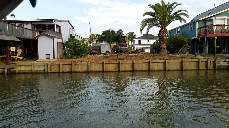
A continuous run of walls
A whole street of bulkheads is the strongest signal imagery can give you. It means the authority on this lake permits shoreline reinforcement, and that this stretch of bank qualifies for it.

It depends entirely on who controls your shoreline — and that changes completely from one lake to the next. Here is how Dave works out the answer, starting with a check you can run yourself in five minutes.
It is the first question on every waterfront lot, and it almost never gets a straight answer.
Whoever built your lake generally still controls the land around it, and that is what decides your project — not the county, and not the city your mail comes to. On one reservoir a boathouse is a routine application. Two hours away, on water that looks identical, there is no application to make at all.
The cost of guessing is real. People commission drawings, order material, and occasionally close on a lot before finding out that the structure they were picturing cannot be permitted where they want it. Dave would rather tell you that on the first phone call than take a deposit for something that will never get built.
There is no statewide rulebook to look it up in. A Corps of Engineers reservoir, a river authority lake, a city-owned water supply, a private lake company and a power-plant cooling pond all answer the same question differently, and all of them sit within a couple of hours of Trinity. What follows is the order Dave works through — cheapest evidence first.
Before a survey, before a call to an agency, before anyone draws anything, Dave looks at the shoreline from above. Existing structures are the cheapest evidence there is, and you can pull them up on a laptop tonight.
That is the whole logic, and it is more reliable than it sounds: permission leaves a physical record. If a stretch of bank is lined with bulkheads and covered slips, somebody applied and somebody approved it. The job then becomes finding out who issued those permits and whether they still are.
Google Earth Pro for desktop is free, and it is the one worth having — sharper imagery at close zoom, a measuring tool, and the historical imagery slider. Type the property address straight into the search box.
Keep going past the point where the lot lines make sense, until individual structures resolve. You are not looking at your house yet. You are looking at the water's edge.
A hard, straight line where the lawn meets the water is a bulkhead. A roof standing out over the water is a boathouse. Both mean the same thing — this shoreline has been permitted before.
Drag a mile each way, then run the historical imagery slider back twenty years. When the walls appeared matters as much as whether they are there.
Imagery is evidence, not permission. It is very good at telling you what has been allowed, and poor at telling you what is allowed today.
A whole street of bulkheads is the strongest signal imagery can give you. It means the authority on this lake permits shoreline reinforcement, and that this stretch of bank qualifies for it.
Covered slips and boathouses mean over-water structures have been approved here at some point. Whether they are still being approved is the next question, not a settled one.
This proves less than people assume. It can mean the lake is closed, or that the ground is federal, or simply that nobody has asked. Treat it as a reason to call, not as an answer.
Run the slider back. If every wall on the lake predates 2005 and nothing has been added since, the shoreline may have closed in the meantime — and that is worth asking about directly.
Federal, regional, municipal or private — Texas has all four, and each runs a different process with a different rulebook.
Almost every lake in Texas was built by somebody, for something: flood control, water supply, power-plant cooling, or a neighborhood. Work out which of those it was and you are most of the way to knowing whose approval you need.
On federal reservoirs the U.S. Army Corps of Engineers owns a band of land at the water outright and holds a flowage easement over private ground above it. Each lake has its own shoreline management plan, which is why Sam Rayburn and Bardwell Lake can sit in the same state, under the same agency, and permit completely different things.
River authorities run their own shoreline programs — the Lower Colorado River Authority on the Highland Lakes, the Brazos River Authority at Possum Kingdom, the Trinity River Authority at Livingston, the San Jacinto River Authority at Conroe, the Sabine River Authority at Fork and Toledo Bend, and the Guadalupe-Blanco River Authority on the Guadalupe chain. Same idea in each case, six different application packets.
Then there are the lakes a city owns outright, the lakes where the city owns your lot and leases it back to you, and the handful held by private water companies whose rules are stricter than any agency's. Every one of those is a live example on this site.
Each card links to a lake page where that arrangement is written out in full, with the office and the process named.
Federal flood-control and water-supply reservoirs. The Corps owns land at the water in fee and holds a flowage easement above it. Every lake has its own shoreline management plan, so the answer is lake-specific and often zone-specific within one lake.
The LCRA, Brazos, Trinity, San Jacinto, Sabine and Guadalupe-Blanco authorities each run a shoreline permitting program on the lakes they operate. Approval comes before construction, for a specific location — not after the fact.
The Tarrant Regional Water District holds the shoreline on Cedar Creek, Richland-Chambers, Eagle Mountain and Bridgeport. Same principle as a river authority: the district that owns the water owns the permit.
Municipal water supplies where the city is the authority. Houston controls Lake Houston. Arlington licenses its shoreline by calendar year and makes you reapply annually. Fort Worth runs dock and boathouse work through an appendix to its building code.
On some small city lakes you lease the ground your dock stands on. Roughly 300 Gladewater lake lots are leased rather than sold, and Weatherford works the same way. Your lease is the rulebook — read it before anyone draws anything.
Cherokee Water Company owns the lake and every lot around it. A permit is required before building, repairing or altering any structure, and none is issued on a lot that has not been surveyed by a Texas RPLS and tied to the company's control network.
Cooling reservoirs are private industrial property. There is no permit counter at Squaw Creek or Martin Creek because there is no public process at all — anything on that water is arranged with the operator, or not at all.
Some water has no single counter. Choke Canyon involves Reclamation, the City of Corpus Christi, the Nueces River Authority and TPWD. Joe Pool is federal land leased out as parks. Working out who leads saves a great deal of wasted design.
The ground is privately owned. The Government holds the perpetual right to put water over it. That combination is what catches owners out.
When a reservoir was built, the Government bought the land that would sit under the lake outright. Over the ground above that line — the ground that only floods when the lake comes up — it bought an easement instead: the permanent right to flood it. You own the dirt, pay taxes on it, and mow it. They kept the right to put water on it, and with that comes a say over what you put there.
Ordinary use and upkeep of the ground is yours. On Corps flowage-easement land an owner may mow, clear, fence, plant and sell without asking anyone.
No structure for human habitation may be built on flowage-easement land. On a Corps lake that is a flat prohibition, not a hurdle to negotiate.
Everything else — a bulkhead, a retaining wall, a ramp, fill. Each takes the prior written approval of the District Engineer, applied for with a letter, plans showing elevations, and a location map.
The elevation is the part people underestimate. The easement stops at a surveyed contour, that contour is a different number on every lake, and it is frequently missing from deeds and plats — which is exactly how an owner ends up planning a structure they cannot build. The line on the survey governs, not the line the water happens to be making the day you walk the lot. A wall built a few feet the wrong side of it is a very expensive mistake, so Shoretech establishes that boundary before drawing rather than assuming it.
There is no point designing around a permitting path that does not exist. These are the cases where the honest answer comes first.
Power-plant cooling reservoirs are the clearest case. Squaw Creek was impounded to cool the Comanche Peak nuclear plant and is operated by a private company. Martin Creek was built by the utility that runs the Martin Lake generating station, and that company still owns it. Neither has a city permit office, a county dock ordinance, a river authority program or a Corps shoreline management plan. There is nothing to apply to. If someone tells you there is a permit desk for one of these lakes, ask them to show you where.
Then there are public lakes closed to new private structures. Lake Ray Roberts has effectively no private waterfront dock development at all. Bardwell has no private-dock shoreline. At Lake Grapevine the Lake Office states that new boathouse permits will not be issued, so the boathouses that exist are the ones there will be — and a rebuild has to match the original footprint or be smaller.
None of that means there is no work. On lakes like these the real projects sit behind the line: retaining walls, erosion control and slope stabilization on ground you genuinely own, plus repair and rebuild of structures that already carry an approval. That is a smaller conversation than the one most owners arrive with, but it is a real one.
Lake Lewisville is the case that shows why imagery alone is never the last word.
For years, bulkheads on Lewisville were built by contractors who did not know how to build them. Walls leaned, backfill washed out, and sections went into the lake. The Corps of Engineers responded the way you would expect and stopped permitting shoreline reinforcement on the lake altogether.
A property owner pushed for an exception. Permitting that single job took a year. Dave submitted the design, the Corps reviewed it, the wall went in, and then they came out and inspected it. On the strength of that inspection they authorized one contractor rather than reopening the lake to everyone. Shoretech is currently the only contractor permitted by the Corps of Engineers to build shoreline reinforcement — steel or heavy timber bulkheads — on Lake Lewisville, and that authorization runs through the end of December 2027, renewable.
New boathouses and docks on Lewisville remain unavailable. The lake is closed to new private docks and open to bulkheads only through that authorization, which is the part worth taking away: a shoreline can look shut from above and still have a specific, narrow path through it. Imagery tells you what was possible. Whether it is possible now, and through whom, is a phone call.
Start with who built the lake and why. Flood control usually means the Corps of Engineers. Water supply usually means a river authority, a water district or a city. Cooling water means a power company. A neighborhood lake often means a private lake corporation. Once you know that, you know whose rules apply — and Dave can usually tell you from the address.
No, and it is not meant to be. It tells you whether structures have ever been permitted on that water, which is worth knowing before you spend anything. It cannot tell you whether permits are still being issued, where your federal boundary falls, or what your particular lot allows. Treat it as the first five minutes, not the answer.
Privately owned ground the Government holds the perpetual right to flood. On Corps lakes you may mow, clear, fence, plant and sell it. You may not put a structure for human habitation on it, and any other structure needs the prior written approval of the District Engineer. The easement stops at a surveyed elevation that is often missing from the deed.
Usually it is a good sign, and occasionally it is not enough. Their wall may predate a rule change, sit on a differently classified stretch of shoreline, or have been permitted under a program that has since closed. It is a strong reason to make the call — not the permission itself.
Shoreline reinforcement, yes. Shoretech is currently the only contractor the Corps of Engineers permits to build steel or heavy timber bulkheads on that lake, through the end of December 2027. New boathouses and docks are not available at Lewisville under current Corps guidance — see the Lake Lewisville page for the full picture.
On the lakes where there is a program to apply to, yes — we prepare and manage the package as part of the project, with plans drawn to the standard the reviewing office expects. Where there is no public process, we will say so rather than invent one.
Call anyway. The lakes written up here are not all the lakes we work, and Dave travels as far as the right project warrants. Send the address and he will look at it exactly the way he looks at the ones that are.
He will tell you what is possible on that water — including when the answer is nothing, which is worth knowing before you pay anybody for drawings.