Bulkhead Replacement & Repair
Galvanized steel, vinyl, FRP composite and heavy timber walls for frontage that takes the basin's reach — with the tiebacks, deadmen and drainage that decide how long the next wall lasts.

The courthouse square is seven miles from the water. The waterfront that carries a Livingston address is a string of east-shore communities — Memorial Point, Indian Hill and their neighbors — facing the widest part of the lake. That is the shoreline this page is about.
County seat of Polk County since 1846, the largest town in the county, and the commercial center of the whole lake region — sitting east of the water it is named for.
Livingston is where the lake region does its business — the US 59 and US 190 junction, the banks, the lumber yards, the county offices. What it mostly is not is lakefront: the city center sits roughly seven miles east of the reservoir. The waterfront lives in named subdivisions with Livingston mailing addresses strung along the east shore, and each one is its own small jurisdiction with its own gate, ramp and rules.
The flagship is Memorial Point — a gated community of 205 acres, 512 lots and about 4,000 feet of lakefront, with its own property owners association and even its own utility district, created in 1971 as the lake filled. Indian Hill Estates and Indian Hill No. 2, off Indian Hill Boulevard, sell on unobstructed open-lake views, and Indian Hill No. 2 keeps an active association of its own. Lake Livingston Village and Lake Livingston Estates round out the roster.
The geography those views come from is the design problem. The east shore fronts the main basin at its widest — the lake runs about 31 miles down the drowned Trinity valley and reaches 9 miles across here, with TPWD putting maximum depth at 77 feet. Held at a constant pool, that much open water works a shoreline at the same elevation every day of the year, which is why an east-shore bulkhead is engineered as an exposed-water structure, not a pond wall.
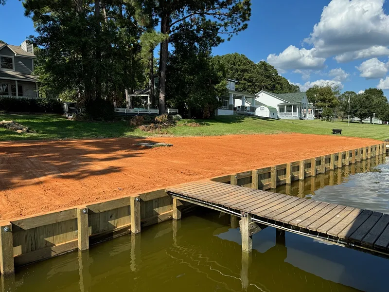
The Milburn timber shoreline bulkhead — built by Shoretech on Lake Livingston, the reservoir these east-shore communities front.
This is home water for Shoretech, based up the lake in Trinity: more than 40 years of marine construction, over 250 boathouses and 850-plus projects. What holds on an exposed shoreline is mostly what you cannot see — embedment, tiebacks and drainage — the difference between a wall built to last and the leaning one it replaced.
Every structure on this stretch gets designed for basin exposure first, then carried through the TRA authorization as one project.
Galvanized steel, vinyl, FRP composite and heavy timber walls for frontage that takes the basin's reach — with the tiebacks, deadmen and drainage that decide how long the next wall lasts.
Covered slips, lifts and entertainment decks sized inside the general permit's limits — 2,500 square feet in plan view including overhangs, no covered second story, storage capped at 200 square feet.
Fixed piers built tight to constant-level water, out to 150 feet or one third of a cove's width, whichever the permit allows on your frontage.
Slip and access-channel depth restored under Nationwide Permit 19 with the TRA dredging application — a separate authorization, since dredging sits outside the general permit and prop-washing is prohibited outright.
Trinity River Authority — Lake Livingston permits office, 936-365-2292 · applications through the Lake Livingston Project online portal on MyGovernmentOnline.
The Trinity River Authority holds fee ownership of the lakebed up to elevation 131 feet, so a dock or bulkhead at an east-shore lot stands on TRA ground. Authorization comes through USACE Galveston District General Permit SWG-2007-00720, administered locally with TRA as the Corps designee — signed January 2023, running through December 31, 2028, and valid across the lake in Polk, San Jacinto, Walker and Trinity counties.
The application is a genuine engineering package: plan-view drawings with dimensions and property-line relationships, a cross-section showing deck height above pool and water depth at the terminal structure, the waterfront width of the lot, distance to any navigable channel, and mapped aquatic resources within 50 feet. When a property sells, the authorization must be transferred in good faith to the new owner, with a copy to the Galveston District — worth checking on any lake house purchase before closing, not after.
Layers on top: the City of Livingston (936-327-4311) inside city limits, Polk County development permitting beyond them, and each POA's own architectural review at the gate. The dam — 2.5 miles long, about seven miles southwest of town — is TRA's to run; emergency spillway stabilization was completed in January 2025, design of the permanent repairs is underway, and lake operations continue at normal pool.
Behind each gate is a different POA, a different ramp, and a different set of rules stacked on the same TRA authorization.
Memorial Point runs its own utility district alongside its POA — two boards, one address. Indian Hill No. 2 keeps its own association as well. For a contractor that means gate clearance, road rules and architectural review are part of the schedule from day one, and Shoretech builds them into the plan rather than discovering them at mobilization.
The town itself is not — the courthouse square sits roughly seven miles east of the water, at the US 59 and US 190 junction. The waterfront is the string of east-shore subdivisions carrying Livingston mailing addresses: Memorial Point, with 512 lots and about 4,000 feet of lakefront behind its own gate; Indian Hill Estates and Indian Hill No. 2, marketed on open-lake views; and Lake Livingston Village and Lake Livingston Estates. That shoreline is where this work happens.
A real package. The general permit calls for the completed application form, copies of any prior authorizations for the site, a vicinity map, a plan-view drawing with structure dimensions and property-line relationships, a cross-section showing deck height above pool and water depth at the terminal structure, the waterfront width of the lot, the distance to any navigable channel, and mapped wetlands or vegetation within 50 feet. Shoretech prepares and files it through the Lake Livingston Project online portal; the permits office answers at 936-365-2292.
It is supposed to move with the property. The general permit requires a good-faith transfer of the authorization when the property sells — the new owner signs and a copy goes to the USACE Galveston District. The flip side is just as firm: an owner who abandons a structure must remove it entirely and restore the site. Buying an east-shore place with an existing boathouse, ask for the authorization paperwork alongside the survey.
No. This is a constant-level water-supply reservoir held near the 131-foot pool with only one to two feet of annual fluctuation, and there is no seasonal drawdown program — the temporary lowering during the 2024-25 spillway stabilization was a one-off emergency measure, and operations continue at normal pool. The stable level cuts both ways: construction elevations are predictable, but the wall takes wave action at the same waterline year after year.
Mostly the site. Wall height and run length, the soils behind the wall, exposure — east-shore frontage faces the widest part of a lake up to nine miles across — water depth at the face, material choice from heavy timber to galvanized steel, access through a gated community, and permit-driven details like driven or jetted pilings. The honest way to price that is standing on the bank, so it starts with a site visit with Dave, not a number over the phone.
Tell Dave which community the lot is behind, what is standing on the frontage now, and how the water works it in a south wind. The design, the TRA package and the POA review get handled together — and the structure gets engineered for nine miles of open basin, because that is what it will live in front of.